NORTHPORT, Mich. (Michigan Back Roads) – The last community going north up the Leelanau Peninsula is Northport, Michigan. The road continues north to the tip of the peninsula, and along the way is the trail to Cathead Bay. That leads to the Manitou Overlook.
The trail is part of a system located in a new section of Leelanau State Park, at the end of Densmore Road. There are several trails that begin at the parking area, and all of them are very well marked. For Cathead Bay, follow Spur 1. The trail is fairly smooth through gently rolling terrain. The area is forested with tall beech, white birch, and pines, with a scattering of other hardwoods. There are a couple of small hills to negotiate as the trail winds through the forest.
MORE NEWS: Monroe Community College: Gender-Inclusive Restroom Signs Not Helping With Safety
This trail follows the contours of the landscape, affording great views of several ravines. At each juncture with other trail spurs, is an excellent map sign that shows the options. After less than a mile, you reach the stairs to the overlook. The stairway is only about 30 steps, but it is steep. At the top is an overlook which rewards the climb with an unequaled view of the dunes, and the Manitou Islands in the distance. Plan ahead for sunset watching since this is a popular spot for that.
If the stairs are too much for you, there is another unique flat shoreline trail nearby. Drive further north to the tip of the peninsula and enter the State Park. From the parking area, it is just a short walk out to the Grand Traverse Lighthouse. This lighthouse guided ships through the Manitou Passage of Lake Michigan, for nearly 150 years. The lighthouse has a museum representing a keeper’s home, and several other exhibits. The old foghorn station is also on the grounds and is used for demonstrations. There is a pathway that goes out to the shoreline, past the old Fog Signal Building, and winds back to the grounds of the lighthouse.
The trail is narrow and is made mostly of stone, but it is smooth and easy to walk. The trail winds along the shore of Lake Michigan, through stands of Pussy Willows, low shrubs, and small trees. The entire walk is only about a quarter mile, but there are gorgeous views of the distant islands, and the lake. The variety of birds found here is amazing. If you are early, the benches make this a comfortable spot to watch the sunrise.
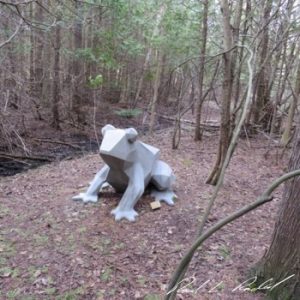
Perhaps the least known trail in the area is the Nagonaba Nature Trail, found right in Northport. Beginning in town, the 3/4-mile trail curves through some unique habitats, and ends at Morningside Drive, near the Braman Hill Recreation Area. The trail was designed to give access to three areas, each with different natural characteristics. The first part goes through larch, tamarack, and pine trees with a small bridge across Northport Creek. It is in this section where everyone stops for a selfie with a big cool sculpture, Jeremy the Frog, the work of a local artist.

In the spring season this area will be covered in marsh marigolds, and jack-in-the-pulpit peaking up through the wetlands. The next two areas include a section of cedars, hemlocks, and quaking aspen trees. Then comes a section of hardwoods including ash, beech, and maple. There are small signs along the way, to help with tree identification, and boardwalks protect the low wet areas. A spur leads to a wooded ridge. The sign says it is steep, and that one should be sure-footed. That is an understatement.
A Bit of History:
MORE NEWS: Many Still in the Dark, Utilities Say It Will be Days Before Power Returns
Northport Creek, a designated trout stream, was known as Big Sucker Creek back in the day. The Nagonaba Trail was named for one of three Native Americans who accompanied the Rev. George N. Smith when he moved to the Leelanau Peninsula from Allegan County. The name may have been spelled “Nagonabe”.
Directions:
The Cathead Bay Trail access is on Densmore Road, just north of the Woolsey Memorial Airport.
The in-town access to Nagonaba Trail is at the west end of Nagonaba Street about 4 blocks from downtown Northport.
